
.jpg)


Services r@h
Robotics
Four New Innovative Services for Structural and Site Monitoring
We are pleased to introduce four new technology-based services designed to help monitor and document the condition of structures and surrounding terrain more efficiently, safely, and accurately than ever before. Operators of hydropower plants benefit from state-of-the-art methods such as robotic inspection, drone surveying, and digital 3D modeling to support well-informed decisions and optimized processes.
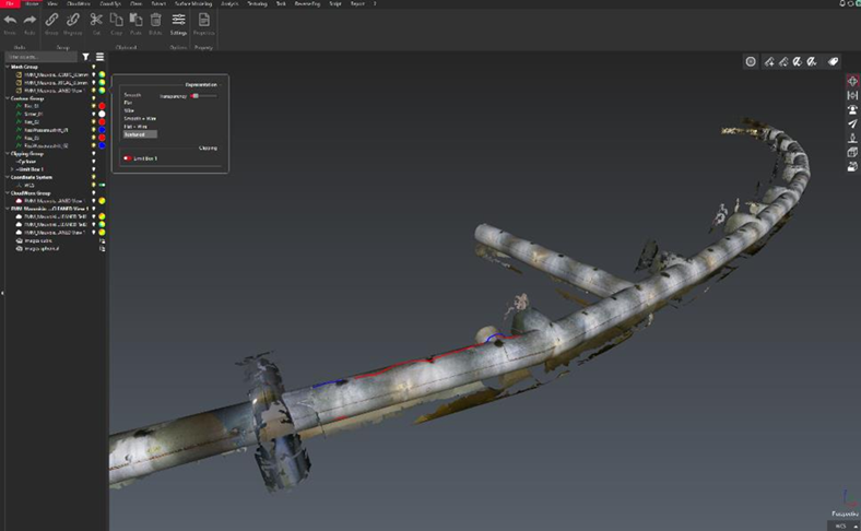
Underwater Structural Inspection
Our underwater inspection service offers operators of hydraulic structures a flexible and risk-free alternative to conventional underwater inspections. Where traditional methods such as dewatering or diver missions are often costly, time-consuming, and risky, our robotic technology enables the rapid collection of detailed, high-resolution condition data using remotely operated underwater robots or cameras. Plant teams receive video, image, sonar, or 3D model data without any operational interruption or safety risk—supporting targeted planning of maintenance and rehabilitation. Expert analyses can be provided as needed.
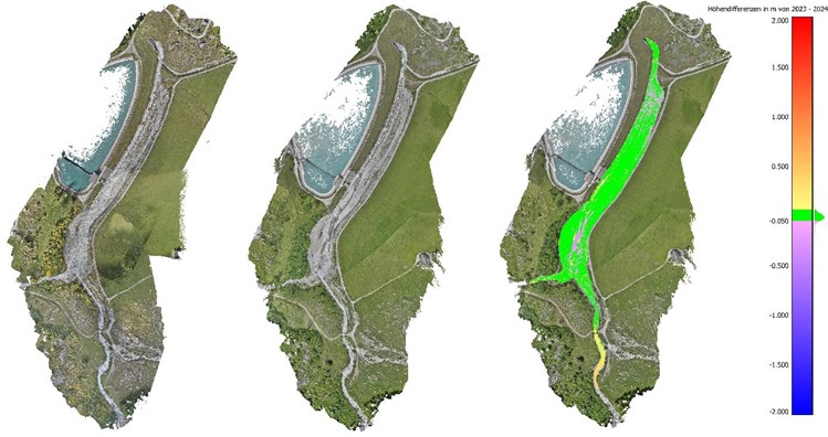
Terrain Monitoring and Natural Hazard Detection
For operators of dam structures needing to monitor terrain changes and natural hazards, we offer terrain deformation monitoring. Instead of the traditional, often labor-intensive and risk-prone point-based monitoring, we use drone-based photogrammetry or laser scanning to capture broad-area data. Plant teams gain precise information about movements and volume changes—safely collected from the air or ground, without requiring on-site inspections. The resulting detailed models enable solid analyses and condition assessments, with expert evaluations also available upon request.
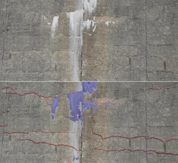
Surface Inspection of Concrete Structures
Surface inspection addresses the limitations of traditional manual documentation, which is often time-consuming and makes precise localization of features difficult. This service creates a digital visual feature registry of concrete surfaces through automated 3D reconstruction and feature analysis. Operators of concrete structures, such as dams, gain remote access to precise, objective, and digitally available condition data at any time. This efficient and cost-saving solution enables monitoring and detection of changes over time and can be complemented with expert evaluations.
Digital As-Built Documentation of Structures and Terrain
Our digital as-built documentation simplifies refurbishment, renovation, or new construction projects at existing sites, where accurate digital plans of current conditions are often missing. Using 3D laser scanning or photogrammetry—drone-based or terrestrial—we rapidly and precisely capture the as-is condition. Project owners, planners, and operators receive detailed digital 3D models, point clouds, and 360° images as a reliable planning foundation. These datasets enable virtual walkthroughs and can serve as a basis for BIM models.
Interested in these new services and their added value for ongoing or future projects? A personal consultation demonstrates how modern monitoring and documentation technologies can be applied effectively.